oC
![]()
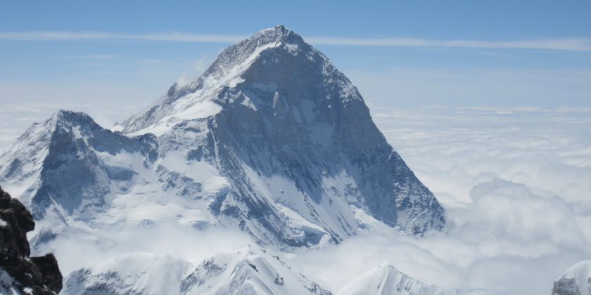
The fifth highest mountain in the world, Makalu Expedition is a part of the Mahalangur Himalayas that lies southeast of Mount Everest on the border between Nepal and China. An isolated peak, Makalu’s shape is a four-sided pyramid. Kang Chun Tse and Chomo Lonzo, the two notable subsidiary peaks of Mount Makalu also add an ethereal feel to the peak. Makalu was first submitted on May 15, 1955 by Lionel Terray and Jean Couzy of a French expedition. Makalu is one of the harder eight-thousanders, and is considered one of the most difficult mountains in the world to climb. The mountain is notorious for its steep pitches and knife-edged ridges that are completely open to the elements. The final ascent of the summit pyramid also involves technical rock/ice climbing. Notable feature of visiting Mount Makalu is the beautiful Makalu-Barun Valley.
A Himalayan glacier valley situated at the base of Makalu in the Sankhuwasabha district of Nepal, the Makalu Barun Valley lies entirely inside the Makalu Barun National Park. Brimming with stunning contrasts, where high waterfalls cascade into deep gorges, craggy rocks rise from lush green forests, and colorful flowers bloom beneath white snow peaks, the valley has a unique landscape that shelters some of the last pristine mountain ecosystems on Earth. Relatively undisturbed by human kind, rare species of animals and plants flourish in diverse climates and habitats.
With its name derived from the Sanskrit word “Maha Kala”, Makalu is a name of the Hindu God Shiva that translates to “the Big Black” in literal English. Due to its isolation, Mount Makalu receives few trekkers- making it an off-the-beaten-paths destination. With Gurung, Rai and Sherpa people inhabiting the region, Makalu Base Camp Trek is a journey that is culturally rich and provides unique biological and traditional treasures of the Makalu Barun area. Barun Valley is also a sanctuary for animals like wolves, lynxes, foxes and beautiful snow-leopards.
Traditionally there are 3 camps, C1 (6,500m), C2 (7,300m) at the bottom of the Southeast Peak ridge and C3 (7,900 m) at the beginning of the SE ridge. With very low Base Camp the BC is set-up at 5500m. The terrain encountered on the ascents varies from glacier crossings to steep snow fields and requires a good understanding of basic alpine climbing techniques. Makalu has climbed Alpine style but traditionally all commercial operators practice expedition style to improve the chances of summit success for the clients. The bottom part starts from the base of the West Face at 5,800 meters and climbs to the hanging ice-fall at 6,100 meters to the right part of the ice-fall. The second part extends from the plateau above the ice-fall along 35 to 45 degree elevation’s rock up to the 6,500 meters high.
The next section is an ice-rock wall, 50 to 55 degrees steep & that extends to 7,400 meters height. The last final section begins 70 to 75 degree elevation’s rock pillar, which leads to the west ridge at 8,000 meters height till to the top of the summit. Ropes are typically fixed from 5800m to 6100m and from 6500 m to 7500m. Camps established by the Russian Team were at the following locations. The French Route on the West Pillar is an aesthetically stunning line that has been seldom attempted. It is an exceedingly difficult, a very steep pillar that was first successfully ascended in 1971. The crux of the line comes at approximately 7,600m in the area of the Seignior Wall.
Makalu has many interesting routes leading to the summit via west ridge, west face, south face, southwest face and northwest buttress. The normal commercial route is past the Southeast Peak and along the Southeast ridge. The climb is straightforward but moderately technical with exposure on the SE Ridge; it requires some fixed rope set-up.
You will take a flight from Kathmandu to Tumlingtar and then take a jeep to Num passing through Haruru.
You will continue along the trail descending steeply from Num through the corn fields of Lumbang. Below the village the trails drop very steeply through a jungle to a suspension bridge over the Arun river. From the bridge we climb steeply to a primitive tea shop, then through corn and buckwheat fields. Moving along the rocky path and tiny terraces planted with corn and barley, we make a long, steep, rough climb to Sedua.
Leaving Sedua, you will make a gradual climb high above the Kasuwa Khola to Gyang (1770m). Climbing past the school at Gyang, it is a gentle walk through terraced fields and forested areas to Hindringham village, and on to Rupisa. En route, you will cross meadows and several streams, and then climb to the Sherpa village of Tashi Gaon.
You will climb over the ridge and ascend through forests to a stream and onto a ridge where there is a small campsite. The trail levels out, and then climbs to a shepherd’s hut called Chipla atop another ridge. You will have to climb past two small streams, then switch back up the ridge in forests to a Kharka at 2900 meters and up to a saddle and unshisha, a tiny meadow at approx. 330 meters. Here the trail joins the ridge that separates the Iswa and Kasuwa drains. The slope gets steeper and becomes a series of moss-covered stone stairs to Dhara Kharka, a meadow atop the ridge. Then you have to move over a hillock and descend a bit to reach Kauma.
Today leaving Kauma, you will climb on steep switchbacks for a while. Then you have to climb less steeply through rhododendron forests to the top of the ridge, with a large mani wall adorned with prayer flags. From here, you get superb views of Chamlang, Peak 6 and Peak 7. Following the ridge for a while, you will have to ascend a stone staircase.
After a few false summits the trail veers left off the crest to a small lake. Then you have to climb gently up a shallow rocky gully to the Kike La (4127 m). From the pass, you have to descend to another lake, then ascend steeply through large boulders to Tutu La. You will continue descending about 150 meters into sparse rhododendron forests to a level area. The final descent is through a forest of firs and rhododendrons to Mumbuk (3570 m). Mumbuk is a forest camp, on a grassy slope about 100 meters above a small stream, with views of snow peaks through the trees.
You will descend a steep gully with a stream for about 500 meters. Then you move left through fir forests, along the flank of the Barun Valley. Moving along an ill-defined trail, you will cross a 200-meter-long slide area, and then follow the river to a Kharka. Moving through forests of birch and scrub rhododendron, you will reach Yangle Kharka. You will Climb from Yangle Kharka, finally crossing to the north side of the Barun Khola to reach Nhe Kharka. There is a small Gompa at the south side of the valley that offers great mountain views.
Beyond the Nhe Kharka, you will follow the north bank of the Barun Khola for a while. Then you will cross a small wooden bridge before the river turns northward. The Barun Valley makes a huge S-shaped curve and the walls rise almost vertically 1500 to 2000 meters above the river, but the trail climbs gently as you approach Ripok Kharka. Still on the north side of the Barun, the trail turns westward and leaves the rhododendron forests for alpine tundra.
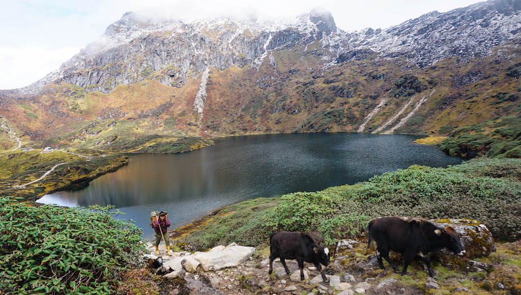
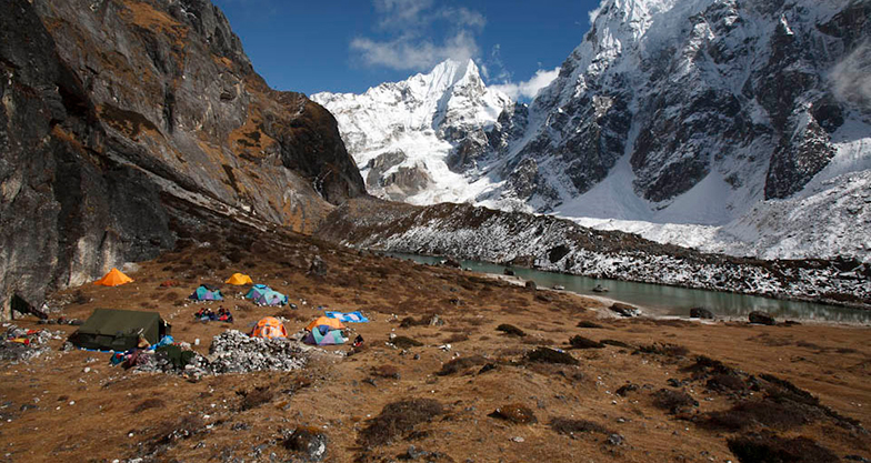
Above Ripok Kharka, the route crosses a rocky crest with a few goths, and then ascends alongside a moraine formed by the Barun Glacier. There are excellent views of Pyramid Peak, Peak 4, Chamlang, Peak 3 and Peak 5, but Makalu is not yet visible. As you pass a ridge the glacier turns slightly north. You will enter an alluvial valley and Makalu pops into view just before Sherson (4615 m). Sherson is somewhat sheltered, but still is a very cold spot.
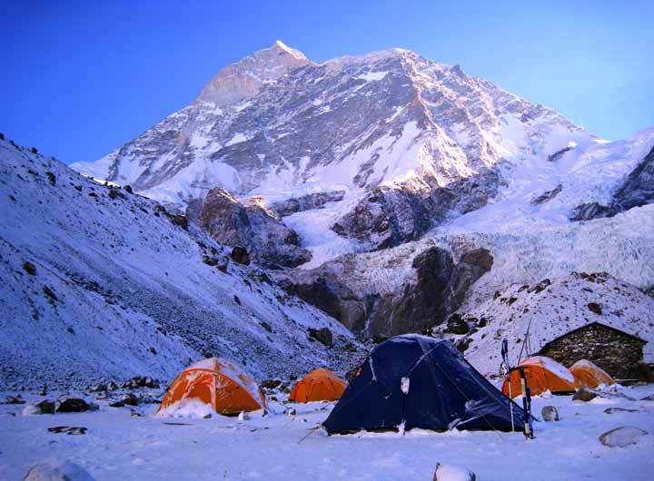
From Sherson, you will have to stay to the right in the gully on the east side of the valley. It is a gradual descent to a minor pass about 100 meters above Makalu Base Camp. Then you will have to descend to a stream, cross on boulders to the base camp on the west bank of the river. From here you will get terrific views of the south face of Makalu. The large buttress of the south face rises across from base camp. An ascent of this buttress yields views of Peak 6, 7 and Baruntse, Everest and Lhotse complete the panorama.
You will spend several days doing climbing training practices with adequate days for proper acclimatization. The Sherpa crew will do all the hard work of setting up additional camps at higher altitudes. Fully equipped with all the climbing equipment and with proper acclimatization you will follow the guidance and instructions of experienced climbing experts. You will tackle several technical climbing sections and taking weather conditions into consideration you will head towards the summit of Mount Makalu – the 5th highest peak of the world. Once at the summit, you are rewarded with breathtaking views of the world’s towering mountains including Everest, Lhotse, Cho Oyu, Nuptse, Baruntse, and several other high peaks in the Mahalangur region. You will spend short quality at the summit and descend following the same route back to Base Camp.
Having achieved your target – the summit of Mt Makalu, you will prepare for your return journey. All set to go, you will leave Makalu Base Camp and begin to retrace your steps on the trail that passes through Shersong and Nehe Kharka. From Nehe Kharka a rather easy trail will lead you back to Mumbuk for your overnight camping.
After breakfast, you will pack your gears and leave Mumbuk. You will continue to retrace your steps on the same trail that heads back through the crossing of minor passes before reaching Kauma Danda. From there you will trek for some time and arrive at Tashigaon for overnight camping.
You will descend the Kasuwa Khola Valley back to Sedua, then turn south down the west bank of the Arun River. From Sedua, you will follow a trail that descends gently to Mulgaon, and then drop steeply on a rocky trail through fields of corn and barley to the Ipsuwa Khola, crossing it on a suspension bridge at 760 meters elevation. The route now enters the hot bottom lands of the Arun Valley. Most of the settlements in this area are temporary settlements used by Rai and Chettri farmers who live in villages high on the hillside above. Passing the villages, you will continue along the trail through rocky fields to Balung.
The trail continues through temporary farming settlements to the spread-out Rai village of Walung (880m). The trail descends to the Apsawa Khola and crossing it on a suspension bridge, you will have to climb steeply to Chhayang, a pleasant Rai village with an extensive bamboo-pipe water supply at 800 m. It then crosses a stream at 590m and makes some ups and downs to reach Parangbu, a delightful camping spot among rice fields on the banks of the Arun River. You will continue through forests and pass several small streams to reach Pukuwa.
The trail now follows a route through forests and some spectacular high and exposed narrow tracks as it climbs over rocky ridges. The route eventually enters a region of intense valley bottom cultivation, crosses a huge landslide and some more scrub jungle before descending to Tome (520 m). Below Tome, the Arun Valley becomes wider and more U shaped. The trail climbs over another ridge on a steep, narrow stairway of rock steps. From the top of the ridge at 530m, the trail descends to a delightful camp on the banks of the Sankhuwa Khola (370m), across from the Chhetri village of Bumling.
The trail traverses the fields of lower Bumling, then climbs over a ridge and descends to the Inkhuwa Khola, crossing it on a rickety wooden cantilever bridge. The trail follows the river downstream to its confluence with the Arun. It then follows Arun downstream, crossing it on a large suspension bridge. Now following the east bank of the Arun, the route passes through Chyawabesi before making a short climb back to the Tumlingtar plateau. It is a few km of complete level walking to the airstrip.
The flight takes about 30 minutes to reach the Kathmandu Valley. You will be accompanied by scenic flight views and clouds.
Shopping is my option in contrast to Red Bull. Regardless…
Hundreds of years of preservation and perseverance, nourished and timely…
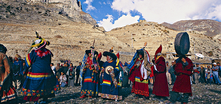
Among the many 12 years festivals Nepal has, Lha Phewa…