oC
![]()
Makalu Base Camp Trek is a beautiful journey that lets you taste the real adventure of walking inside the Makalu Barun National Park to Makalu Base Camp. The region offers some magnificent views of mountains like Mt. Makalu with other peaks like Mt. Everest, Mt. Lhotse and Mt. Baruntse. The lush scenery of Arun Valley is probably the most beautiful thing that will keep you going throughout your journey. Though many people keep their interest in this trek, Makalu region attracts only few travellers during a year due to its remote accessibility and off the beaten trekking trail. Taking about the difficulty on the way and trail, the trail to Makalu Base Camp is never flat. You will either be ascending up or descending down which makes the trek difficult and tiring.
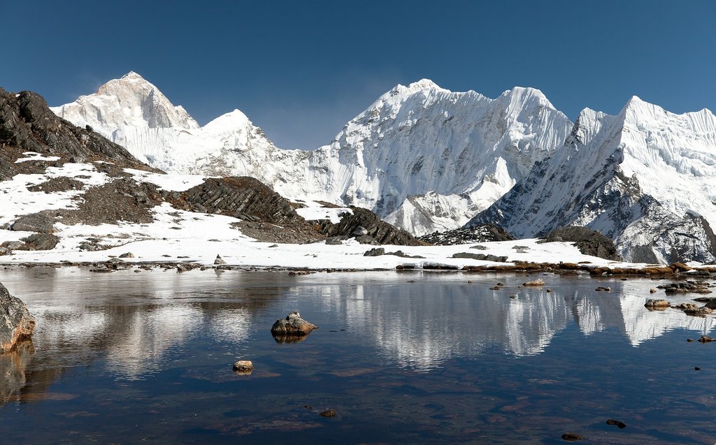
But the difficulty that you faced along your way is nothing as compared to the magnificence of nature that you will enjoy. The rhododendron forests, beautiful cliffs, glaciers and stunning waterfalls that you encounter in the way will make your trek full of wonders and excitement. As you stand tall in the Makalu Base Camp, all you can do is let your eye wander from one peak to another with the majestic Mt. Makalu rising tall right in front of your eyes. You can encounter some rare birds and animals in your journey if lucky. Similarly, interaction with local people on the way will give us some insights on their culture, lifestyle and tradition. People here are engaged in agriculture for livelihood. You can see beautiful fields as you pass through villages. The people are friendly which makes your journey more lively and homely. Makalu is the fifth highest mountain in the world (8,481m), yet the trek to its base camp is a less-frequented route due to its relative inaccessibility.
Deeper into the mountains, past the Barun River Valley, you will pass steep granite cliffs, glaciers, and spectacular waterfalls. At the higher elevations live the Sherpa people, an ethnically Tibetan group who predominantly reside near Everest. From Makalu Base Camp there are spectacular views of the rarely seen Kangshung face of Everest, as well as Lhotse, Chamlang, and Kanchenjunga in the far east. The Makalu Barun National Park is the eighth largest in Nepal, covering 2,330 sq. km, and is home to some of the rarest flora and fauna in Nepal, including the Red Panda. The trek starts in warm, terraced farmland inhabited by the Rai people, an ethnic group found predominantly in the hills of eastern Nepal.
You will take a flight from Kathmandu to Tumlingtar and then take a jeep to Num passing through Haruru.
You will continue along the trail descending steeply from Num through the corn fields of Lumbang. Below the village the trails drop very steeply through a jungle to a suspension bridge over the Arun river. From the bridge we climb steeply to a primitive tea shop, then through corn and buckwheat fields. Moving along the rocky path and tiny terraces planted with corn and barley, we make a long, steep, rough climb to Sedua.
Leaving Sedua, you will make a gradual climb high above the Kasuwa Khola to Gyang (1770m). Climbing past the school at Gyang, it is a gentle walk through terraced fields and forested areas to Hindringham village, and on to Rupisa. En route, you will cross meadows and several streams, and then climb to the Sherpa village of Tashi Gaon.
You will climb over the ridge and ascend through forests to a stream and onto a ridge where there is a small campsite. The trail levels out, and then climbs to a shepherd’s hut called Chipla atop another ridge. You will have to climb past two small streams, then switch back up the ridge in forests to a Kharka at 2900 meters and up to a saddle and Shisha, a tiny meadow at approx. 330 meters. Here the trail joins the ridge that separates the Iswa and Kasuwa drains. The slope gets steeper and becomes a series of moss-covered stone stairs to Dhara Kharka, a meadow atop the ridge. Then you have to move over a hillock and descend a bit to reach Kauma.
Today leaving Kauma, you will climb on steep switchbacks for a while. Then you have to climb less steeply through rhododendron forests to the top of the ridge, with a large mani wall adorned with prayer flags. From here, you get superb views of Chamlang, Peak 6 and Peak 7. Following the ridge for a while, you will have to ascend a stone staircase. After a few false summits the trail veers left off the crest to a small lake. Then you have to climb gently up a shallow rocky gully to the Kike La (4127 m). From the pass, you have to descend to another lake, then ascend steeply through large boulders to Tutu La. You will continue descending about 150 meters into sparse rhododendron forests to a level area. The final descent is through a forest of firs and rhododendrons to Mumbuk (3570 m). Mumbuk is a forest camp, on a grassy slope about 100 meters above a small stream, with views of snow peaks through the trees.
You will descend a steep gully with a stream for about 500 meters. Then you move left through fir forests, along the flank of the Barun Valley. Moving along an ill-defined trail, you will cross a 200-meter-long slide area, and then follow the river to a Kharka. Moving through forests of birch and scrub rhododendron, you will reach Yangle Kharka. You will Climb from Yangle Kharka, finally crossing to the north side of the Barun Khola to reach Nhe Kharka. There is a small Gompa at the south side of the valley that offers great mountain views.
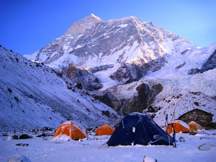
Beyond the Nhe Kharka, you will follow the north bank of the Barun Khola for a while. Then you will cross a small wooden bridge before the river turns northward. The Barun Valley makes a huge S-shaped curve and the walls rise almost vertically 1500 to 2000 meters above the river, but the trail climbs gently as you approach Ripok Kharka. Still on the north side of the Barun, the trail turns westward and leaves the rhododendron forests for alpine tundra. Above Ripok Kharka, the route crosses a rocky crest with a few goths, and then ascends alongside a moraine formed by the Barun Glacier. There are excellent views of Pyramid Peak, Peak 4, Chamlang, Peak 3 and Peak 5, but Makalu is not yet visible. As you pass a ridge the glacier turns slightly north. You will enter an alluvial valley and Makalu pops into view just before Sherson (4615 m). Sherson is somewhat sheltered, but still is a very cold spot.
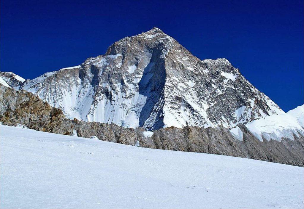
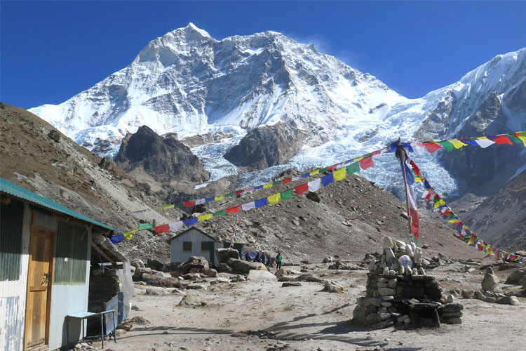
From Sherson, you will have to stay to the right in the gully on the east side of the valley. It is a gradual descent to a minor pass about 100 meters above Makalu Base Camp. Then you will have to descend to a stream, cross on boulders to the base camp on the west bank of the river. From here you will get terrific views of the south face of Makalu. The large buttress of the south face rises across from base camp. An ascent of this buttress yields views of Peak 6, 7 and Baruntse, Everest and Lhotse complete the panorama.
You will retrace your steps down the Barun Valley towards Nhe Kharka.
From here, you will continue to descend through the forests to Mumbuk. From here you will get beautiful sunset views of Makalu and Chamlang.
You will trek across the Shipton La and descend to Kauma.
This day you will make a long steep descent back to Tasgaon. At Kashigaon you will spend the rest of the day relaxing in order to recover from high altitude.
You will descend the Kasuwa Khola Valley back to Sedua, then turn south down the west bank of the Arun River. From Sedua, you will follow a trail that descends gently to Mulgaon, and then drop steeply on a rocky trail through fields of corn and barley to the Ipsuwa Khola, crossing it on a suspension bridge at 760 meters elevation. The route now enters the hot bottom lands of the Arun Valley. Most of the settlements in this area are temporary settlements used by Rai and Chettri farmers who live in villages high on the hillside above. Passing the villages, you will continue along the trail through rocky fields to Balung.
The trail continues through temporary farming settlements to the spread-out Rai village of Walung (880m). The trail descends to the Apsawa Khola and crossing it on a suspension bridge, you will have to climb steeply to Chhayang, a pleasant Rai village with an extensive bamboo-pipe water supply at 800 m. It then crosses a stream at 590m and makes some ups and downs to reach Parangbu, a delightful camping spot among rice fields on the banks of the Arun River. You will continue through forests and pass several small streams to reach Pukuwa.
The trail now follows a route through forests and some spectacular high and exposed narrow tracks as it climbs over rocky ridges. The route eventually enters a region of intense valley bottom cultivation, crosses a huge landslide and some more scrub jungle before descending to Tome (520 m). Below Tome, the Arun Valley becomes wider and more U shaped. The trail climbs over another ridge on a steep, narrow stairway of rock steps. From the top of the ridge at 530m, the trail descends to a delightful camp on the banks of the Sankhuwa Khola (370m), across from the Chhetri village of Bumling.
The trail traverses the fields of lower Bumling, then climbs over a ridge and descends to the Inkhuwa Khola, crossing it on a rickety wooden cantilever bridge. The trail follows the river downstream to its confluence with the Arun. It then follows Arun downstream, crossing it on a large suspension bridge. Now following the east bank of the Arun, the route passes through Chyawabesi before making a short climb back to the Tumlingtar plateau. It is a few km of complete level walking to the airstrip.
The flight takes about 30 minutes to reach the Kathmandu Valley. You will be accompanied by scenic flight views and clouds.
Shopping is my option in contrast to Red Bull. Regardless…
Hundreds of years of preservation and perseverance, nourished and timely…
Among the many 12 years festivals Nepal has, Lha Phewa…